Why a City Map Needs More Than Street Names
A city map needs more than street names. Learn how symbols, scale and the map key reveal routes and public places, and help you choose the right map.
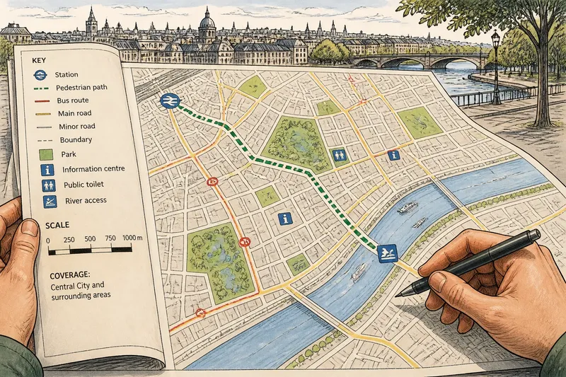
A city map’s symbols, scale and key can change what a reader understands about a route. Street names locate roads, but they do not show every footpath, public facility or connection between districts. Reading those other marks carefully helps distinguish a useful route from a line that only suggests one.
City map symbols
Symbols stand in for features that would be awkward to label in full at every location. A small pictogram might mark a station or public toilet; a coloured line might trace a bus route; a dashed line might denote a footpath. Their meaning depends on the map, so shape or colour alone is not enough.
Maps also select which features to show. A transit map may emphasise routes and stations while omitting building types. A public-facilities map may show libraries and parks but leave minor streets in the background. That selection is editorial: it directs attention towards the question the map is designed to answer.
Look for symbols that remain distinct when printed small or viewed on a dim screen. If two marks look alike, check the key rather than inferring meaning from colour. A photocopy may lose colour contrast, while shape and line pattern can remain legible.
Reading the map key
The map key, also called a legend, pairs each mark with its stated meaning. Find the mark in the key, then compare it with the one on the map. A dashed line, for instance, could mean a footpath on one map and a boundary on another.
Check the title and any coverage notes as well. They tell you whether the map concerns public transport, land use, walking routes or another subject, and which area it covers. If a mark is missing from the key, do not assign it a meaning by guesswork; consult the map’s notes or choose a map that explains the feature.
City map scale
Scale relates a distance on the page to the corresponding distance on the ground. A city-wide map covers a broad area, so it generally simplifies local detail. A neighbourhood plan can show smaller paths and connections more clearly, but covers less territory.
Scale affects what appears, not just how large it looks. At a broad view, a narrow lane may be omitted, while a main road is prominent. Its absence does not by itself show that the lane is closed or unusable; the map may simply leave out detail that does not serve its purpose.
Use the scale bar, when provided, to judge distance rather than estimating from the apparent size of a street. Also compare the map’s subject and coverage before deciding that two maps disagree: they may show different levels of detail or different kinds of public connection.
Choosing a city map?
Is a street map enough for a route?
It may show named roads without showing footpaths, transit links or access points. Check the key and coverage before treating the visible street route as the only available connection.
Why do city maps differ?
Maps can use different scales, purposes and symbol systems. Compare their titles, keys and coverage notes before assuming that a feature has moved or disappeared.
What if a symbol is unclear?
Check the key, then read the title and notes for the map’s subject and area. If the mark is not explained, avoid inferring its meaning from colour or shape alone.
Can one map show every connection?
No single map can show every route, entrance, service and boundary while keeping all its marks legible. Use a map suited to your question, and treat a simplified route as an indication of a connection rather than a complete account of every turn.
Checking a city map
Before relying on a map, check the details that determine what its marks can tell you:
- Check the title for the map’s subject; if it focuses on transport, use it for route context, but choose a facilities map to locate public services.
- Check the coverage notes for the area shown; if your destination falls outside it, find a map that includes the full route.
- Check the key for the route symbol; if it identifies a footpath, consider that connection, but if it is unexplained, do not assume it is walkable.
- Check whether the scale bar is present and legible; if it is, use it to judge distance, but if it is absent or unclear, consult a map with a usable scale before estimating.
- Check whether a route is drawn as a solid or dashed line and what the key assigns to each; if the pattern indicates a proposed route, do not treat it as an existing path, but look for a map that distinguishes current routes.
- Check whether similar symbols remain distinguishable in the copy you are using; if they do not, consult a clearer version or a map whose shapes and line patterns separate those features.
Say you need to walk from a station to a riverside destination. In this invented situation, the starting information is a city map whose key defines dashed green lines as pedestrian paths, a station symbol, a river-access symbol and a scale bar. First, you find the station and destination symbols, then trace the dashed line between them. The key indicates that the line represents a pedestrian path, so the map supports a possible connection; the broad city view and simplified line do not show every turn or entrance. The resulting decision is to use the map to understand the route’s general relationship, then consult a more detailed local map if you need to follow the path precisely.
Making marks readable
A readable map balances labels and symbols. Street names identify locations; line patterns and pictograms distinguish routes and places; the scale limits how much local detail can fit; and the key explains the visual choices. Like a bus timetable, a map works only when its marks have a clear meaning and the reader can find the explanation quickly.
For a city map, start with the question you need answered: where a route goes, which public facilities appear, or how streets connect across an area. Then check the key, scale and coverage. Those details help you tell what the map actually describes—and where you need a more specific one.